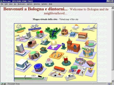
Cities are geographic centres of people, activities and services. The urban form and layout of cities are familiar to most people. Consequently, the virtual city is being used as an interface metaphor to information and services on the WWW. Virtual cities provide an electronic hub of services, activities, information and people located at a single "place" on your computer screen, just like real cities are a focal point in geographic space.
In this article we shall begin by discussing the nature of virtual cities, before examining ways of creating, on the Web, three-dimensional models of the buildings for virtual cities. We will conclude by looking at current research into creating "true" virtual cities with realistic built form, useful information content and, importantly, a sense of urban life.
In addition to the VRML route a number of innovative companies offer proprietary VR modelling technologies that are being used in virtual city construction. One of the most interesting is produced by Superscape (http://www.superscape.com/) which CompuServe is using to create virtual cities for online shopping. Figure 3 shows a screen-shot of their "out-of-town" virtual retail park.
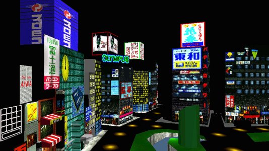
Figure 2 : Planet 9 Studios's Virtual Tokyo
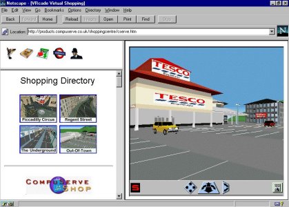
Figure 3 : CompuServe's 3D virtual retail park
(http://products.compuserve.co.uk/ShoppingCentre/cserve.htm).
The three-dimensional models are downloaded from the Web onto your computer and you are then able to freely explore the streets and view details from any angle. Whilst the use of these types of Web-based VR technologies provide an important step towards the creation of virtual cities by providing the means to create realistic 3D built form, the examples above are a long way from being "true" virtual cities because they do not contain any depth of information behind the interface and they do not support any social interaction, they are merely three-dimensional models.
To give virtual cities a real sense of life they must support social interaction through face-to-face meetings, discussion or just chatting. This can be achieved by enabling the 3D built form of the virtual city in multi-user environments whereby any number of users can be present in the same model. Each user within the virtual city model is represented by an avatar. An avatar is the user's representation of their bodily presence in the virtual city. Although avatars represent the user they need not necessarily look like them or even have human form for that matter. Avatars are under user control, they move as the user navigates around the virtual city. When multiple users are in the virtual city, via their avatars, they can meet and talk to one another. Talking is via a "chat box" on the computer interface where one is able to type messages to other people in real-time. Although "talking" by typing text messages is somewhat cumbersome, it is a popular and well tried method of communication on the WWW. Through the ability to meet and talk to other people in the virtual city, it is hoped the a measure of life and spontaneity found in real cities will develop.
A screen-shot from one of CASA's virtual city prototypes called 'Wired Whitehall' is shown in figure 4. This has realistic built form for the Whitehall area of central London, in a multi-user environment provided by a system from Blacksun (http://www.blacksun.com/). Two user avatars are featured in the model, talking to each other using the "chat box" along the bottom of the window.
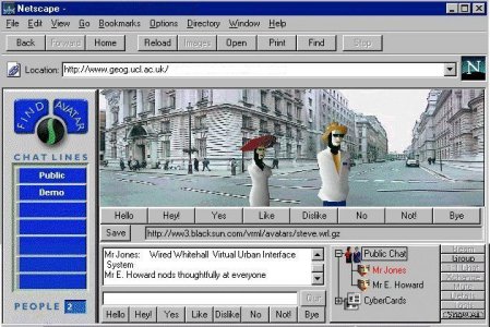
Figure 4 : CASA's "Wired Whitehall" prototype.
We also believe that to be a true virtual city its built form needs to be geographically referenced, with all its elements appropriately represented in some form of object-orientated spatial database. For the GIS community virtual cities could be a potential "next-generation" three-dimensional interface to object-orientated spatial databases. The virtual city in essence becomes an information system in which multiple users could enter and walk through and query. For example, you could use your avatar to query the information system by touching a building.
The virtual city information system concept has a great deal of scope for applications. The research in CASA for example is particularly focused on the application of these technologies to improve the planning, design and management of real cities. The virtual city information system could be used by a wide range of groups, from developers looking for sites for new buildings, local authorities and utilities planners in the management of the urban infrastructure, to provide tourists with detailed guides, and for residents as a community resource. The particular style of interface and the level of detail of information presented could be tailored to suit the needs of the user group concerned. A particularly exciting application of the virtual city information system could be to provide an integrated and intelligible user interface to the huge volumes of data being captured by real-time systems like road traffic sensors, pollution monitors, building management systems and CCTV.
The prospect of creating true virtual cities, with a real sense of urban life, that people can visit from anywhere in the world and at any time are tremendously exciting. Perhaps the virtual city will be the city for the 21st century!
Andy Smith, Martin Dodge and Simon Doyle are researchers in the Centre for Advanced Spatial Analysis (CASA) at University College London, 1-19 Torrington Place, Gower Street, London, WC1E 6BT. Tel : 0171 391 1782, Fax: 0171 813 2843, Web: http://www.casa.ucl.ac.uk Email: asmith@geog.ucl.ac.uk / m.dodge@ucl.ac.uk / s.doyle-walsh@ucl.ac.uk