| [To the 1950's ...] |
 |
[To the 1950's ...] |
|
19 |
 |
63 |
|
Development of Canada Geographic Information (CGIS) commences,lead by Roger Tomlinson. The system was needed to analyse Canada's national land inventory and pioneered many aspects of GIS.[More...] |
 |
|
|
|
|
The Urban and Regional Information Systems Association (URISA) formed. URISA is non-profit association of professionals using information technology to solve problems in planning, public works, the environment, emergency services, utilities ... [Link...][More...] |
|
19 |
|
64 |
|
The Harvard Lab for Computer Graphics established by Howard Fisher.The Lab was an important research centre, creating pioneering software for spatial data handling.Many of the key individuals in the GIS industry studies there. These inlcude ...[More...] |
|
|
|
19 |
|
65 |
 | |
SYMAP (Synagraphic Mapping Sytem) - a pioneering automated computer mapping application developed byHoward Fisher at the Northwestern Technology Institute and completed in the Harvard Lab[More...] |
|
19 |
|
67 |
|
US Bureau of Census DIME (Dual Independent Map Encoding) data format christened by George Farnsworth. [Link...][More...] |
|
 |
|
|
|
The Experimental Cartography Unit (ECU) established at the Royal College of Art in London by David P. Bickmore.[More...] |
|
AUTOMAP - Automatic Mapping System was developed by the US Central Intelligence Agency (CIA) and became operational at 1967. It could produce castlines and any form of line or point data. It was a map compilation program at the world level.[More...] |
|
|
|
19 |
|
68 |
|
|
|
The Transportation Information System was developed by Robert Tweedie of the N.Y State Department of Transportation at Albany, and was based on grid manipulation. It incorporated, among others, geocoded land use and travel characteristics. The ...[More...] |
|
19 |
|
69 |
|
Environmental Systems Research Institute (ESRI), founded by Jack & Laura Dangermond. [Link...][More...] |
|
 |
 | |
Integraph Corporation founded by Jim Meadlock (orginally called M&S Computing Inc). [Link...][More...] |
|
Laser-Scan was founded in 1969 by three academics from the Cavendish Laboratories, Cambrdige, United Kingdom. [Link...][More...] |
|
 |
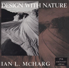 | |
Ian McHarg's influential book Design With Nature was published, popularising the development of map overlay techniques. [Buy...][More...] |
| [To the 1970's ...] |
 |
[To the 1970's ...] |