Viual Reality and Geographical Information Systems, Birkbeck College, 22nd May 1998.
Towards the Virtual City:
VR & Internet GIS for Urban Planning
Martin Dodge*, Simon Doyle*, Andy Smith* & Stephen Fleetwood#
*Centre for Advanced Spatial Analysis (CASA),
University College London
#Chief Executive's Office, City of Westminster Council
Introduction
The emergence of affordable virtual reality and Internet GIS is providing the fundamental infrastructure to begin building virtual cities which can provide an interactive simulation and analysis environment for planning real urban places. The virtual city on the Internet will provide planners with a computer environment to interface with the myriad of complex physical and social data needed to plan and manage cities, along with necessary tools to explore and analyse that data in meaningful and intuitive ways.
On the World-Wide Web (WWW) you can find various instances of 'virtual cities' or digital representations of real-world urban locations. These sites offer a graphic interface to related data, but there are very few which try to integrate virtual reality (VR) technologies with the spatial databases held within Geographic Information Systems (GIS) to create what we see as virtual cities - an effective simulation environment for planners.
We begin by defining virtual cities in relation to the manifestations found on the Web at present. We then outline the emergence of Internet GIS, before considering efforts of leading research teams to construct large 3d model of cities. We then outline a major project to construct Virtual London being undertaken by the authors, showing working prototypes which marry a range of VR and Internet GIS technologies used to simulate the Westminster area of central London (Batty et al 1998).
Virtual Cities on the Web
The city is a powerful metaphor that most people are familiar with. The WWW is primarily a visual interface to information resources; in this context the metaphor of the city, with buildings and its familiar structure of roads and public spaces, is being employed by a number of content providers as a user interface to a range of information, services and facilities. The terms "virtual city", "cybertown", "digital city" abound on the Web, being employed for diverse range of information interfaces and content. However, important distinctions need to be made in the type of "virtual cities" that are currently on the Web. We have developed a three-fold classification (Dodge, Smith & Doyle 1997b) :
a) Web Listing Virtual Cities are Web sites which describe themselves as virtual cities, but in reality are on-line guides, menus and listings. They are often created for advertising purposes, particularly for tourism promotion, usually making little attempt to represent the built form of cities. A typical example being
"Virtual Brighton & Hove" (http://www.brighton.co.uk/).
b) "Flat" Virtual Cities use "flat" image maps of buildings and street as an static interface. A nice example is Virtual Bologna, shown in figure 1, which uses a stylised town map of familiar landmarks and buildings as graphical icons to further online information.
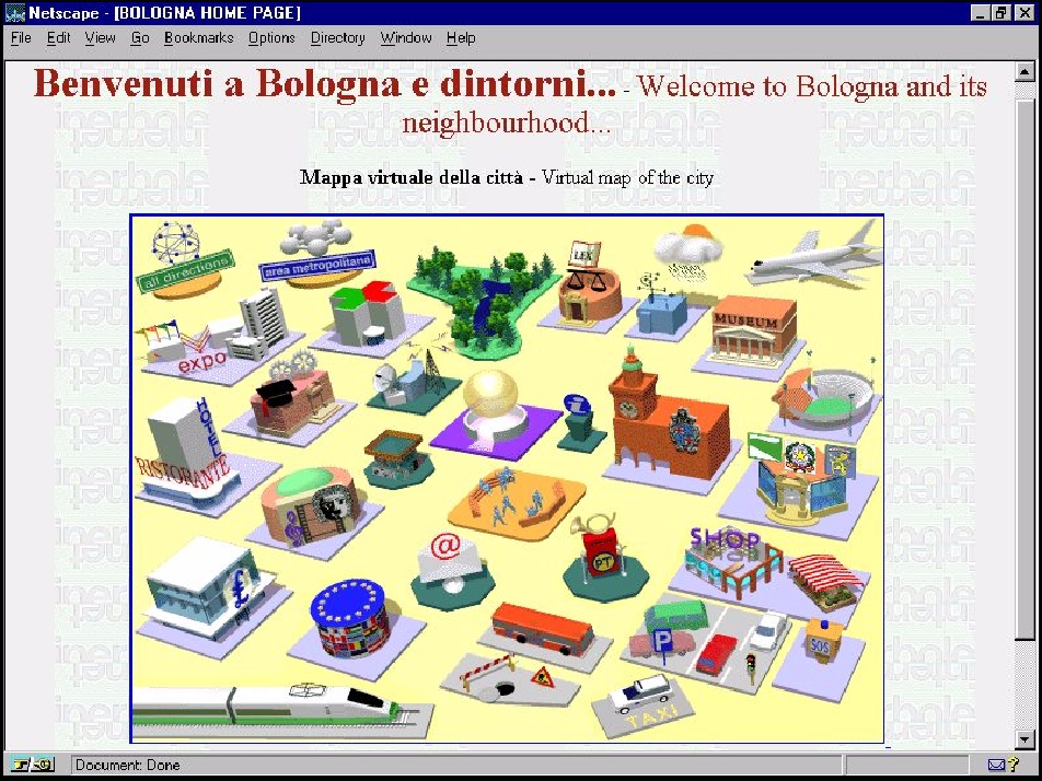
Figure 1 : Virtual Bologna
Source : http://www.nettuno.it/bologna/MappaWelcome.html
c) Three-dimensional Virtual Cities use Web-based VR technologies to model the built form of cities, to varying degrees of accuracy and realism. These cities are usually navigable in the sense that user can walk around and fly through the scene. Buildings are represented as 3d polygons with textures to add realism. Virtual Reality Modelling Language (VRML) is often used to create such sites, although they are seldom compiled using accurate base map data as a foundation and generally only cover small part of the city. Planet 9 Studios is one of the leading companies constructing these types of virtual cities and figure 2 shows a screen-shot of their Virtual Tokyo
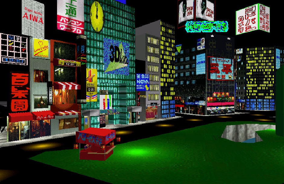
Figure 2 : Plant 9's Virtual Tokyo
Source : http://www.planet9.com/earth/tokyo/index.htm
There are several approaches representing cities on the Web which employ the virtual tag within their title. However, true virtual cities that provide effective digital simulation of real-cities which give users a genuine sense of inhabiting an urban place do not yet exist on the Web. Research in the field of Internet GIS and 3d urban modelling using VR are creating the foundations for true virtual cities with realistic built-form interface, a richness of georeferenced information content, and crucially, the ability to support social interaction with other people.
The Migration of GIS onto the Web
The Internet and the World Wide Web have been hailed in the popular press as revolutionary medium of communication for the next millennium. The Web is opening up new forms of computer-mediated communications, allowing for new forms of information dissemination, social interaction and collaborative working. Many activities can be undertaken within the environment of the Web to their advantage; electronic publishing, journalism, retail and "open" government, to name but a few, are all distinct examples of areas where the Web is being used to reach customers, clients and citizens respectively.
The rapid development of the Internet, as a place of information dissemination provides researchers and policy-makers with considerable challenges on how best to realise the potential in the pursuit of worthwhile goals. This is particularly so for the planning community with the intense drive to develop GIS further in terms of widening and deepening access to spatial information along with appropriate analytical functionality within the network paradigm of the Web and the browser interface. Most GIS vendors and some commercial spatial data providers have realised that the WWW will be the next-generation GIS platform (superseding the conventional PC and desktop paradigms), providing a powerful medium for geographic information distribution, as well as a particularly lucrative new market to exploit (Toon 1997). Plewe provides a timely review of the range of proprietary Internet mapping and GIS that serves as an indicator to the degree of academic and commercial interest in the area to date (Plewe 1997). Internet GIS activity is facilitating innovative development in the dissemination, visualisation and analysis tools for planners of the built environment.
GIS and VR
By adding the dimension of height to building footprint data it is possible to create crude 3d city models, which can be embellished with attribute information in a fashion similar to the way GIS operate on 2d thematic data (Faust 1995, Levy 1995). The traditional mapping and database GIS functionality is being augmented with an array of rich multimedia data (Shiffer 1995) and has certainly added value to the way GIS is used in planning, urban design and as a decision-making tool in general. In this spirit the VR display mechanism and a potentially larger audience.
Recent applied research (Smith, S. 1997, Martin & Higgs 1997) and commercial activity (ESRI 1997) has made advances in the field of VRGIS by making it easier to generating 3d urban models from 2d spatial and thematic data. This will allow the planner to readily create urban models on their desktop.
Building Large Three-Dimensional City Models
The need for realistic 3d models of urban built form is vital to true virtual cities. There are a small number of research groups around the world who are pioneering methodologies and computing tools for constructing realistic 3d models of large areas of urban built form at the city scale. The Urban Simulation Team at the UCLA Department of Architecture and Urban Planning, lead by Professor William Jepson, are creating an interactive city model of greater Los Angeles covering over 4,000 square miles (Liggett et al 1995, Jepson et al 1996). Figure 3 shows a screen-shot of downtown LA created by their virtual city simulator. Their simulation system provides interactive navigation and manipulation tools for end-users, allowing the exploration of alternative planning scenarios over both space and time. The real power of their emerging virtual city is that it "...allows the Urban Simulation Team to include virtually everyone in the planning process, expert and layman alike. We have found that designers, architects, developers and consultants are able to identify real problems and remedy those problems long before the first hole on a new development is dug" (Jepson et al 1996, page 8).
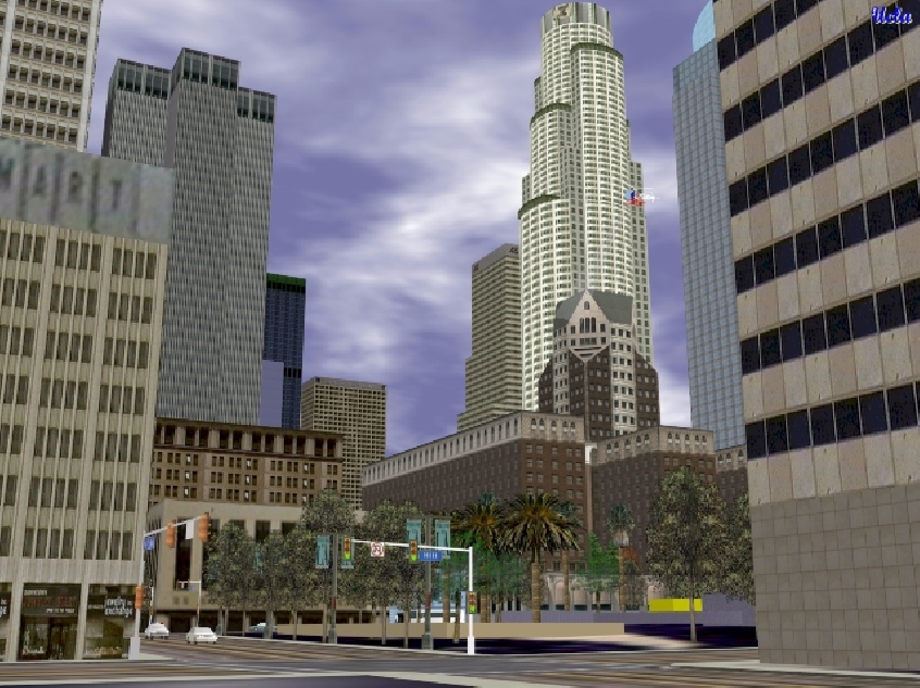
Figure 3 : Virtual LA produced by William Jepson and colleagues in Urban Simulation Team.
Source : http://www.aud.ucla.edu/~bill/UST.html
Another team at the University of Bath, lead by Professor Alan Day have developed a great deal of competence in creating large, realistic city models (Bourdakis 1997b, Day et al 1996). Their most developed model being of the city of Bath, a screen-shot of which is shown in figure 4. The model covers several square kilometres of the historic centre of Bath and is accurate to the sub-metre level. A considerable amount of realism has been modelled using both geometry and texture mapping. Bourdakis, one of the model's creators, comments that the "...computer models were constructed in order to assist in making the planning and development control process more flexible by providing a means by which planning proposals could be visualised and alternative schemes for a site compared; allowing non-experts to comprehend the implications of proposed changes" (Bourdakis 1997a, page 1).
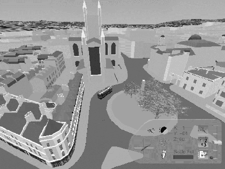
Figure 4 : The Bah Model
Source : http://fos.bath.ac.uk/vas/papers/CAAD-TNDC/
Stephen Kirby and colleagues in the National Key Centre for Social Applications of GIS at the University of Adelaide are developing a 3d GIS model of large area of the city of Adelaide (Kirkby et al 1997). Figure 5 shows an of example screen-shots of the Adelaide model. There are several European research teams working on large urban models. For example the ART+COM organisation has been working on the Virtual Berlin project using virtual reality technologies to model the city (ART+COM 1998). Also in Germany a joint research project between the Universities of Rostock and Stuttgart is developing 3d GIS for urban planning and design, modelling parts of Rostock (http://www.agr.uni-rostock.de/iggi/cebit_e/). While in Austria, an innovative company called GRINTEC is working on 3d city models, they claim that "For decades urban planning was done by drawing plans and building elaborate models from wood and pasteboard, The Austrian cities of Graz and Vienna are demonstrating that this is a thing of the past - its three-dimensional computer simulations derived from information of the digital city map are revolutionising the planning process" (Ranzinger & Gleixner 1997, page 159).
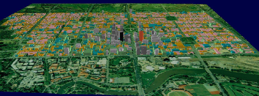
Figure 5 : The Adelaide Model
Source : Kirby et al 1997
Towards the Virtual City for Planning London
The authors are investigating appropriate VR and GIS technologies to create a Virtual London which will have realistic urban form linked to GIS, thus providing a rich simulation environment for geocomputation (Batty et al 1998). We examine a range working prototypes that use a variety of VR and GIS technologies separately and in combination -
- Photospatial VR,
- Internet GIS and 3d thematic block models
- VR pollution surfaces
- Multi-user virtual environments
1. Photospatial VR
Photospatial panoramic VR is a potentially powerful technique for modelling the urban environment (Smith, A 1997), which contrasts to the solid geometric modelling discussed above. A number of software companies have developed photospatial VR systems for use on a variety of operating systems. Apple's QuickTime Virtual Reality (QTVR) is perhaps the most widely used technology for turning panoramic photographs into realistic, navigable scenes that can easily be used over the Web. Professor Michael Shiffer, at MIT's department of Urban Studies & Planning's Computer Resource Lab, developed "The Virtual Streetscape" which pioneered the use of QTVR to model the built environment (Shiffer 1995). The Streetscape prototype illustrates how photospatial panoramic scenes can be linked to urban aerial photography to integrate more traditional, two dimensional images and three dimensional VR scenes.
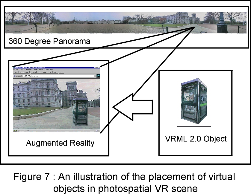
Whilst photographically rendered scenes are highly realistic, the user's view point is fixed to the original location of the camera. The user is not able to 'walk' around the scenes in the same way as in 3d geometric models, however the scenes can be hot-linked together allowing users to 'jump' between them providing a degree of movement. The authors are developing a prototype called "Wired Whitehall" which links together a number of photospatial scenes for the Whitehall area of central London which can be interactively explored on the Web. Figure 6 shows an example scene for Horse Guards, with a virtual object - the phone box - added. The placement of virtual objects within scenes is a particularly useful feature of the technology for urban planning applications. Virtual object placement augments the actual with the proposed thus allowing an end-user to visualise proposed change in a specific location. This technique is encompassed within the broad term of augmented reality and the process is illustrated in figure 7. 'Wired Whitehall' also uses virtual billboards in the scenes to create hyper-links to relevant information. For example, a virtual billboard in the Downing Street scene facilitates access to the "No. 10 Downing Street" Web site.
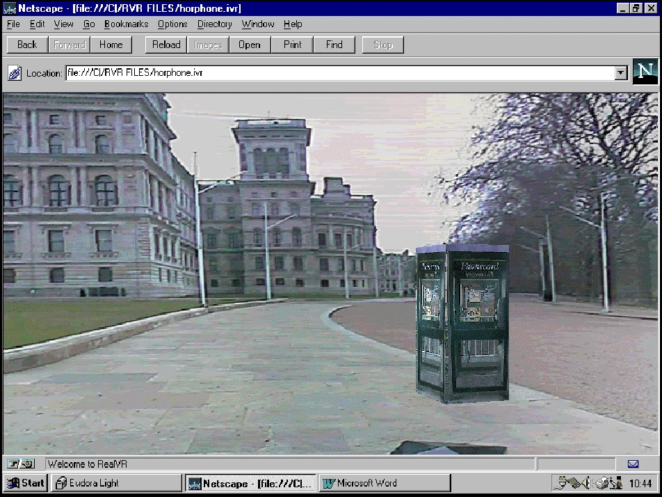
Figure 6 : Photospatial VR - street level scene in Whitehall, with virtual phonebox
2. Internet GIS and 3d Thematic Block Model
By embracing the Web as a dissemination mechanism for geographic information, we can provide alternate representations of urban environments. Figure 8 is an illustration of such an approach. The prototype runs in a standard Internet browser with the frame on the left containing ESRI's MapCafe Java client which browses 2d spatial data drawn from the ArcView Internet Map Server. On the right is a 3d thematic block model, written in VRML, covering the spatial extents of Westminster. The application which has been developed allows a user, potentially anybody with an Internet connection, the opportunity to view 2d data such as census information, aerial photography, vector road network data, or raster surfaces with a basic set of GIS browsing tools. The user is also presented with the opportunity to examine and 'walk around' the 3d thematic model using the standard navigation tools the VRML browser.
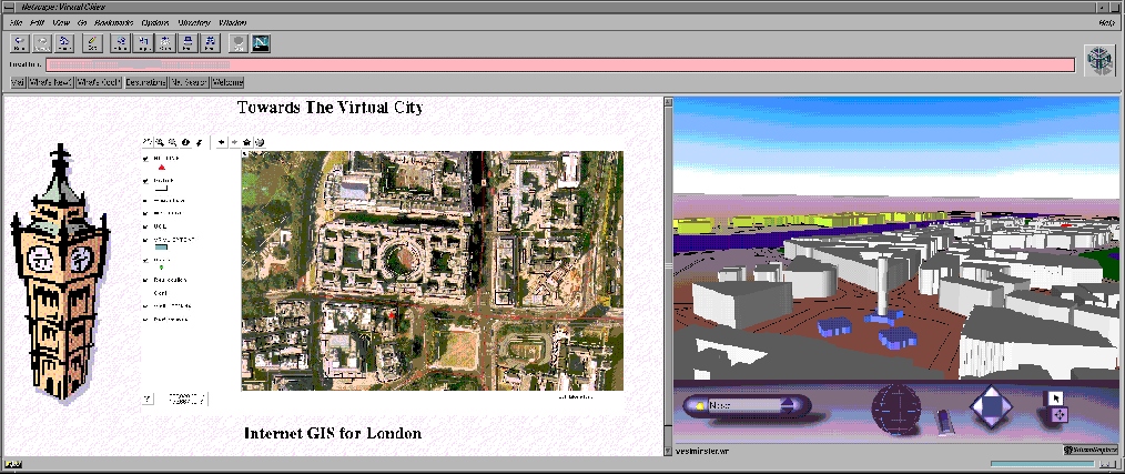
Figure 8 : Internet GIS coupled to a 3d thematic model of Westminster
In this instance building polygons have been thematically coloured according to which planning zone they are located. Within the prototype various 3d models can be displayed and coupled to the Internet GIS. Building heights may be depicted in relation to 3d polygon height, land use may be coded by colour and levels of air pollution may be illustrated as a 3d surface within the model (see below). Furthermore, the model may be viewed in isolation from the map interface and may also be linked to photospatial panoramas which depict street scenes as discussed above.
3. Pollution Surfaces
We are also developing environmental simulation techniques, currently focused on modelling air pollution data for London that is freely available on the Internet. The air pollution data is from the Department of the Environment Transport and the Regions' UK's National Air Quality Information Archive (DERT 1998). This Web site holds an array of raw data on air pollution at a national level which, with monitoring stations being given as an easting and northing co-ordinate pair. As a research exercise it was interesting to see how readily a sample file, relating to the 1995 NO2 diffusion tube study, could be transformed from raw data into a viewable information display. As the raw data consisted of a series of sixty sample points with an x and y location, they could be readily imported and plotted in a two dimensional sense within the GIS. Several further techniques may be applied in order to visualise the data, ranging from choropleth mapping or the creation of proportionate symbols at the sample locations. These approaches were investigated and were found to be rather unstimulating. The images which are displayed in figure 9 were the result of the conversion of the points into a 2d raster surface being themselves converted into a 3d VRML file across the London area. Whilst there are many arguments as to the effects of interpolating surfaces of this nature the point of the exercise was to exploit the raw data on the Web and convert it into a basis for discussion based on the visual qualities of the derived model. This was achieved in terms of having a geo-referenced VRML model which could be flown through or manipulated within in a Web browser.
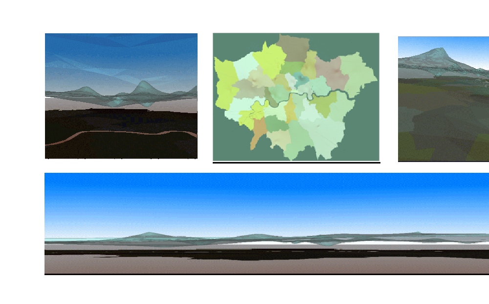
Figure 9 : Virtual Pollution Surface hanging over London.
4. Multi-user Virtual Environments
The techniques discussed so far have all been asynchronous, the user interacts alone with the simulated urban environment. An asynchronous environment, while useful for visualisation per se, limits the potential of VR for use in urban planning as by its nature planning is a shared, collaborative endeavour. Indeed the ultimate goal of virtual cities is the ability to provide a urban simulation environment that can be inhabited by more than one person.
Using software developed by Active Worlds (http://www.activeworlds.com) the authors are developing a Collaborative Virtual Design Studio (CVDS), allowing the use of synchronous communication and interaction in a virtual city for planning and design. CVDS is based on a multi-user virtual world system where users are represented as avatars, providing an all important visual and social presence. Figure 10 illustrates the concept behind the CVDS with the ability to move objects within the virtual environment.
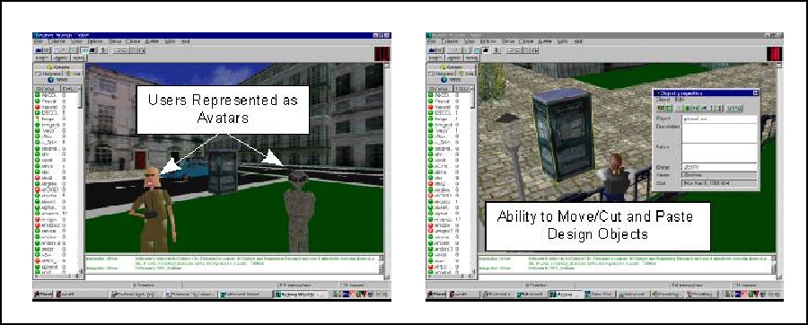
Figure 10 : Virtua design in Alphaworld
As the users interact with each other and the virtual city various powers of "modification" can be permitted such as changing building colours or textures, altering size and plot position, or removing buildings and objects (like street furniture), to create completely new structures and layouts. Planning permissions can also be set in order to determine who has the power to make certain changes to the model (a virtual version of development control). All user activities in the multi-user worlds (avatar movement, action and conversations) can be logged on the server, thus creating extensive metadata on how planning decisions were reached.
Towards the Virtual City
We believe true virtual cities, as set forth in this paper, will emerge as a key tool for planning and managing cities in the Information Age. The foundation of the virtual cities, namely realistic models of built form linked to rich spatial databases housed within a multi-user interactive environment, are being laid today. Technically, it will not be long before virtual cities are available on the planner's and urban designer's desks in the town hall. Once true virtual cities can be delivered over the Web a myriad of interesting possibilities for collaboration, discussion, arguments and debate between the planners and the planned will emerge.
Acknowledgements
The research of Simon Doyle is supported by the Virtual Reality Centre for the Built Environment (VR-CeBEnv) funded by Technology Foresight grant. Martin Dodge is supported by the Virtual Environments for Urban Environments (VENUE) project funded by the Joint Information Systems.
Contact
Simon Doyle, Martin Dodge and Andy Smith are researchers in the Centre for Advanced Spatial Analysis (CASA), University College London, Gower Street, London, WC1E 6BT, United Kingdom. Email :Martin Dodge,Simon Doyle,Andy Smith Telephone: 0171 391 1782. Fax: 0171 813 2843.Web: http://www.casa.ucl.ac.uk/. Stephen Fleetwood is a GIS manager, Chief Executives Office, Westminster City Council, Victoria Street, London.
References
ART+COM, (1998), Virtual Berlin, available at
http://www.artcom.de/contacts/city-and-architecture/berlin.de.shtml.
Batty, M., Dodge, M., Doyle, S., & Smith, A., (1998), Visualising Virtual Urban Environments, CASA Working Paper 1. Centre for Advanced Spatial Analysis, University College London.
Bourdakis, V., (1997), The Future of VRML on Large Urban Models, Proceedings of the Fourth UK VRSIG Conference, edited by Richard Bowden, 1st November 1997,Brunel University.
Bourdakis, V., (1997), Virtual Reality: A Communications Tool for Urban Planning, Proceedings of CAAD: Towards New Design Conventions, edited by A. Asanowicz and A. Jakimowitz, Technical University of Bialystok, pages 45-59.
Day, A., Bourdakis, V. & Robson, J., (1996), Living with a Virtual City, Architectural Research Quarterly, Vol. 2, pages 84-91.
DETR, (1998), National Air Quality Information Archive.
Dodge, M., Smith, A. & Doyle, S., (1997a), Visualising Urban Environments for Planning and Urban Design. AGOCG Graphics, Visualization and the Social Sciences Workshop Report No. 33.
Dodge, M., Smith, A. & Doyle, S., (1997b), Urban Science, GIS Europe, Vol. 6, No. 10, pages 26-29.
ESRI, (1997), Introducing ArcView 3D Analyst : Powerful Tools for Creating, Analyzing, and Visualizing Data in 3D on the Desktop, ARCNews, Spring 1997.
Faust, N.L., (1995), The Virtual Reality of GIS, Environment and Planning B: Planning and Design, Vol. 22, pages 257-268.
Kirby, S.D., Flint, R., Murakami, H., & Bamford, E., (1997), The Changing Role of GIS in Urban Planning: The Adelaide Model Case Study, International Journal for Geomatics, Vol. 11, No. 8, pages 6-8.
Levy, R.M., (1995), Visualisation of Urban Alternatives, Environment and Planning B: Planning and Design, Vol. 22, pages 343-358.
Liggett, R., Friedman, S. & Jepson, W., (1995), Interactive Design / Decision-Making in a Virtual Urban World: Visual Simulation and GIS, Proceedings of the Fifteenth Annual ESRI User Conference, Palm Springs, USA.
Jepson, W., Liggett, R., & Friedman, S., (1996), Virtual Modeling of Urban Environments, Presence, Vol. 5, No 1.
Martin, D. & Higgs, G., (1997), The Visualization of Socio-economic GIS Data Using Virtual Reality Tools, Transactions in GIS , Vol. 1, No. 4, pages 255-265.
Plewe, B., (1997), GIS Online: Information, Retrieval, Mapping and the Internet (OnWord Press: Santa Fe, USA).
Ranziger, M. & Gleixner, G., (1997), GIS-Datasets for 3D Urban Planning, Computers, Environments & Urban Systems, Vol. 21, No. 2, pages 159-173.
Shiffer, M.J., (1992) Towards a collaborative planning system, Environment and Planning B: Planning and Design, Vol. 19, pages 709-722.
Shiffer, M.J., (1995) Interactive Multimedia Planning Support: Moving from Stand-Alone Systems to the World Wide Web, Environment and Planning B: Planning and Design, Vol. 22, pages 649-664.
Smith, A., (1997), Realism in Modelling the Built Environment using the World Wide Web, HABITAT, Vol. 4, pages 17-18.
Smith, S., (1997), A Dimension of Sight and Sound, Mapping Awareness, October 1997, pages 18-21.
Toon, M., (1997), The World by your Window, GIS Europe, Vol. 6, No. 11, pages 38-41.