| [To the 1980's ...] |
 |
[To the 1980's ...] |
|
19 |
 |
91 |
|
Maguire, Goodchild, and Rhind book Geographical Information Systems : Principles and Applications (The GIS "Big Book") was published. [Buy...][More...] |
 |
|
|
19 |
|
93 |
 | |
The GISRUK conference series is the UK's national GIS research conference. GISRUK conferences are primarily aimed at the academic community. They attract delegates from all parts of the UK, together with the European Union and North America ... [Link...][More...] |
|
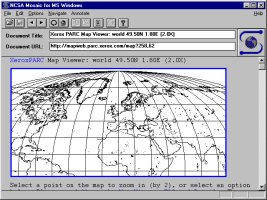
The first Web-based interactive map was developed by Steve Putz and was implemented as as a perl script that accepts requests for map renderings and returns an HTML document including an inlined GIF image of the requested map. It is running ... [Link...][More...] |
|
 |
|
19 |
|
94 |
|
|
|
The University Consortium for Geographic Information Science (UCGIS) is a non-profit organization of universities and other research institutions dedicated to advancing our understanding of geographic processes and spatial relationships through ... [Link...][More...] |
|
19 |
|
95 |
|
MapInfo Professional launched for Windows 95. [Link...][More...] |
|
 |
|
19 |
|
96 |
 | |
The Centre for Advanced Spatial Analysis was established in UCL [Link...][More...] |
|
19 |
|
98 |
|
TerraServer started as a joint research project between Aerial Images, Inc., Microsoft, the USGS, and Compaq. The TerraServer concept grew out of the convergence of two needs. Aerial Images, Inc. wanted to sell imagery online and Microsoft Research ... [Link...][More...] |
|
 |
|
19 |
|
99 |
|
|
|
Longley, Goodchild, Maguire,and Rhind book Geographical Information Systems: Principles, Techniques, Applications and Management(The second edition of the GIS "Big Book") was published. [Buy...][More...] |
| [To the 2000's ...] |
 |
[To the 2000's ...] |